Click here for why you’re getting Sandsday on Da Blog. This strip is part of a series. You may want to start at the beginning. Previous strip. Next strip.

Author and Thinker
 Morgan Wick
Click here for why you’re getting Sandsday on Da Blog. This strip is part of a series. You may want to start at the beginning. Previous strip. Next strip.
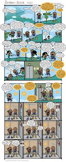
(From The Order of the Stick. Click for full-sized anti-climax.)
Once again, this post has nothing to do with politics, despite my spending two days and a weekend without a word on the subject. I should be returning to it later today.
“I bet everyone was expecting a big battle for strip #600.”
Apparently Grandpa really hasn’t spent much time looking at the world of the living.
There are a lot of things that people were wondering about for strip #600. Perhaps a return peek at Team Evil, with potential huge ramifications, or a look at some other faction we haven’t looked at for a while. Perhaps contact finally being made between the two halves of the Order. Perhaps the prophecied death of Belkar. The previous sequence of strips probably led many to expect either a confrontation or alliance between Vaarsuvius and the imp Qarr. The start of this strip led me to wonder if it was going to end with Roy being called to be resurrected.
But a “big battle”? Not given the state of the OOTS right now, where they’d settle for being in one piece. The closest thing anyone would have predicted to a “big battle” was a confrontation between Haley and the Thieves’ Guild’s Crystal. Maybe, before #599, a confrontation between Vaarsuvius and the rest of that half of the OOTS plus the remnants of the Sapphire Guard.
Since nothing big happened in #600 (unless you count the start of the switch back to Haley, Celia, and Belkar), it’s looking increasingly likely that none of the major objectives of this book will be completed until it’s about over. No resurrection of Roy, no union of the two halves of the Order, no retaking of Azure City, nothing.
Now, given the pace at which Rich Burlew writes, it’s possible that “it’s about over” may be sooner than many of us think. Certainly the union of the Order and resurrection of Roy are things that should probably be taken care of by the end of this book if they are to be taken care of at all. Those are things that need to be set up in turn, and that may take multiple tens of strips. Judging by the last two books, we’d expect this book to end somewhere in the 660s, which means we might expect one of those objectives to be completed possibly as early as the 640s. Or maybe the build will begin about now, considering how much into high gear both plots were starting to move last we checked.
But it’s becoming apparent that this section of the OOTS’ story is going to have far-ranging consequences that could prevent some of those goals from ever being completely fulfilled. This first really became apparent last strip, where Vaarsuvius announced his departure from the ship to find Haley and Roy’s body without distractions, referring specifically to Elan and Durkon. And announcing “I have no intention of returning”. And that he might decide to arrange a meeting between Haley and Elan/Durkon elsewhere… “but probably not”.
It may well turn out that with this action, Vaarsuvius just unilaterally, in an instant, without Roy even being alive to object, kicked Elan and Durkon out of the Order of the Stick. This is especially likely when you consider this strip, in which Vaarsuvius not only fails to grasp who Therkla is but comes to the conclusion that she was Elan’s active girlfriend (despite being present in disguised form when Elan brushed her off). If V can convince Haley of that idea, (s)he might dissuade her from pressing V to chase Elan and Durkon back down.
(Incidentially, early on in my reading of OOTS I had trouble seeing Vaarsuvius as anything but female, partly because of the hair… but as he’s grown more insane and his hair has become more frazzled I’ve found myself using male pronouns more often. Is that worth reading anything into?)
Now comes evidence that Roy hasn’t paid any attention to the travails of Haley, Celia, or Belkar since this strip – he’s still talking about that group having reached Cliffport by now. Which sort of makes me wonder if he’ll even be able to find them. Unlikely, but he will have no idea what’s been going on. (And neither will we. No way “weeks” passed between #572 and the end of our last look-in on Haley/Celia/Belkar.) In a more important development, Roy probably will even be confused by something in evidence towards the end of the last check of Haley and Co.: the curse of the Mark of Justice potentially starting to wane from Belkar.
And there are other far-ranging consequences that have been built for a while that seem inevitable. Vaarsuvius’ insanity won’t be fixed just by finding Haley, or even by finding Haley and a good, long trance, because the last strip seems to suggest V has given up trances for good. Belkar’s been afflicted by the curse of his Mark of Justice and “will draw his last breath – ever – before the end of the year. (That’s an “in-comic” year, not a real-time year, Oracle fans!)” Unless Roy keeps all his memories of what happened while he was dead, including his memories of his conversation with the Oracle, it’s likely that, at the least, something important will happen before he’s resurrected.
It is even entirely possible that no one’s predictions on the future or ending of the comic are correct, because they all assume that the composition of the Order at the end of the strip will consist of some combination of Roy, Haley, Durkon, Vaarsuvius, Elan, and Belkar, and almost always all of the above. The revelation that Belkar’s death would come “before the end of this [in-comic] year” first put a wrench in those plans, but one could easily deal with that. But now that it’s possible that, for the moment, Elan and Durkon are no longer members of the Order, we could be looking at a semi-full-fledged Order of the Stick at the end of this book that shares only Roy and Haley with the Order of the first 500 strips or so (with V insane or even a god, Belkar dead, and Celia officially one of the new members), one that spends as much if not more time trying to find and rope back Elan and Durkon than trying to foil Xykon’s plot. And the prospect of a very different Order of the Stick becomes especially chilling when you consider the Oracle’s prediction of a “happy ending – for [Elan], at least”. If Elan is no longer a member of the Order, what does that say about the Order?
And who’s to say this wasn’t an incredibly important strip… in its very lack of importance?
I’ve finally condensed the label list, so the sidebar should be significantly shorter. (Could that sentence get any more alliterative?) That means, among other things, Da Blog Ad will now be significantly higher up the page. Considering adding a new element for single-label RSS feeds, but I’d like to have a box where you type in the name of a label, or select it from a drop-down, and automatically get that label’s feed, and that would require more coding than I have time for at the moment.
Hmm… it appears this is the 100th blog news post.
Freehostia’s servers are moving to a new data center in the name of better performance, which means I can’t make any changes to the web site in the meantime. I never did get around to updating the lineal titles; the Princeton-Yale title is now Oklahoma State’s after their upset defeat of Missouri (potentially torturing Texas by delaying their shot a week), the 2008 BCS title is now in the hands of Florida, and the NFL lineal title is in the hands of the upset-scoring Cleveland Browns. Hopefully this won’t affect the release of next week’s rankings.
Obviously this also means for the remainder of the week, you’ll need to hit up Da Blog to catch the latest strips.
All times Eastern.
| Top 25 Games | ||||
| #7 Missouri | @ | #1 Texas | 8 PM | ABC |
| Michigan | @ | #2 Penn State | 4:30 | ESPN |
| #3 USC | @ | Washington State | 3:15 | FSN |
| #17 Kansas | @ | #4 Oklahoma | 3:30 | ABC |
| Mississippi | @ | #6 *Alabama | 3:30 | CBS |
| Baylor | @ | #8 *Oklahoma State | 3 PM | |
| #9 Texas Tech | @ | Texas A&M | Noon | FSN |
| Ohio State | @ | #11 Michigan State | 3:30 | ABC/ESPN2 |
| UTEP | @ | #12 Tulsa | 8 PM | CBS CS |
| #23 Vanderbilt | @ | #13 Georgia | 12:30 | R’com/Y’hoo |
| #14 BYU | @ | TCU | 8 PM TH | VS. |
| Colorado State | @ | #15 *Utah | 2 PM | mtn. |
| Hawaii | @ | #16 Boise State | 8 PM FR | ESPN |
| #18 Georgia Tech | @ | Clemson | Noon | ESPN |
| #19 North Carolina | @ | Virginia | 3:30 | ABC/ESPN2 |
| Wisconsin | @ | #20 Iowa | Noon | BTN |
| #21 Wake Forest | @ | Maryland | Noon | Raycom |
| #22 Nebraska | @ | Iowa State | 12:30 | VS. |
| Arkansas | @ | #25 Kentucky | 7 PM | ESPNU |
| Watchlist and Other Positive B Point Teams | ||||
| California | @ | Arizona | 7 PT | FSN |
| Syracuse | @ | South Florida | Noon | ESPN+ |
| Virginia Tech | @ | Boston College | 8 PM | ESPN2 |
| LSU | @ | South Carolina | 8 PM | ESPN |
| Pittsburgh | @ | Navy | 3:30 | CBS CS |
| Florida State | @ | NC State | 7:30 TH | ESPN |
| Connecticut | @ | Rutgers | Noon | ESPNU |
| Oregon State | @ | Washington | 7 PM | VS. |
| Toledo | @ | Northern Illinois | 4 PM | CSN/Gameplan |
| This Week’s Other HD Games | ||||
| Purdue | @ | Northwestern | Noon | ESPN2 |
| Miami (FL) | @ | Duke | 3:30 | ESPNU |
| Stanford | @ | UCLA | 4 PM | FSN/FCS |
| Indiana | @ | Illinois | 8 PM | BTN |
| Big 12 | ||||
| Kansas State | @ | Colorado | 7 PM | FSN |
| SEC | ||||
| Mississippi State | @ | Tennessee | 7 PM | Gameplan |
| Mountain West | ||||
| San Diego State | @ | New Mexico | 6 PM | mtn. |
| Air Force | @ | UNLV | 7 PT | mtn. |
| MAC | ||||
| Miami (OH) | @ | Bowling Green | Noon | ESPN+ |
| Western Michigan | @ | Central Michigan | Noon | ESPN+ |
| Akron | @ | Eastern Michigan | 1 PM | CSD.TV |
| Conference USA | ||||
| Memphis | @ | East Carolina | Noon | CSS |
| Southern Miss | @ | Rice | 3 PM | CBSCS XXL |
| Houston | @ | SMU | 8 PM | CBSCS XXL |
| WAC | ||||
| Utah State | @ | Nevada | 4 PM | Gameplan |
| Idaho | @ | Louisiana Tech | 7 PM | ESPN+ |
| Sun Belt | ||||
| Florida International | @ | Troy | 7 PM | ESPN+ |
| Arkansas State | @ | Louisiana-Lafayette | 7 PM | CSD.TV |
| North Texas | @ | Louisiana-Monroe | 7 PM | CSD.TV |
| Florida Atlantic | @ | Western Kentucky | 7 PM | CSD.TV |
| San Jose State | @ | New Mexico State | 8 PM | Gameplan |
| Bowl Subdivision | ||||
| Middle Tenn. St. | @ | Louisville | 3:30 | Gameplan |
| Army | @ | Buffalo | 3:30 | CSD.TV |
| Marshall | @ | UAB | 4 PM | CBSCS XXL |
The new rankings are up, and links should be fixed to the Week 6 full rankings, but there won’t be an RTF of the full rankings for this week until I post tomorrow’s strip. I should also have a couple more logos up by tomorrow, including TCU’s.
I may have a more substantive post later today turning back to politics and/or global warming/mass transit… or I may not. Coming down with something over the weekend has really played havoc with my plans and I’m still recovering.
For much of the day, from 10 AM to 3 PM PT, an incomplete college football schedule was posted on Da Blog. The full schedule won’t be posted until tomorrow. God willing, the new rankings will be out today.
All times PDT.
Saturday
9-12:30 PM: College Football, #3 Texas v. #1 Oklahoma (ABC). The loser will not play for a national championship. The winner will look good to do so but needs to not screw it up.
12-3:30 PM: College Football, #19 Nebraska @ #7 Texas Tech (FSN). Alternately, Michigan State-Northwestern on the Deuce.
4-8:30 PM: NASCAR Sprint Cup Racing, Bank of America 500 (ABC). It’s the midpoint of the Chase, and I gain the ability to slot in an NFL daytime game! Without help from another sport and with the ability to pick the late (or middle, depending on your point of view) game!
Sunday
10-1 PM: NFL Football, probably Rams @ Redskins (FOX). Just my luck that I finally get a chance at the usually more national late game (or middle game, depending on your point of view), and Fox throws this at me in the early game.
1-3 PM: Champions Tour Golf, Senior Players Championship (NBC). How did I not know of this until just now?!?
5-8:30 PM: MLB Baseball, Phillies @ Dodgers (FOX). NASCAR forces the NLCS to be the LCS of the weekend.
Feeling a bit under the weather and starting writing this post at 8 PM (really 8:40), way later than I had intended, but I will press on regardless.
Many cities have already embraced transit, in the form of urban rail (which I use to refer to variously streetcars, light rail, and “heavy rail” or subways, also “rapid transit”, with the ideas to be presented referring primarily to the latter two), even if not always as a way to counter climate change, but more as a way to chase down economic development and, it sometimes seems, to add a gimmick or tourist attraction to their cities. Just this year there’s a veritable boatload of transit plans on various local ballots. Portland’s heavy investment in transit and other anti-sprawl policies have earned the envy of cities as large as Los Angeles. And Portland is a mid-size city at best, though with its spiffy streetcar and other urban rail systems that could change.
As I outlined in my previous post, mass transit has a ton of many and varied benefits, but it takes some care. Think of two residential neighborhoods in your community far enough apart to be distinct, but close enough to be almost adjacent, not “on the way” to Downtown, and with none or few amenities for people from outside of either neighborhood to visit. If you built a transit line just connecting those two neighborhoods, who would use it? What reason would people in one neighborhood have for visiting someone in the other? Tourists might want to use it but how would they get there from the places that are actually interesting? The problem only expands as we extend it to other uninteresting neighborhoods.
So you can’t just plop down a transit line anywhere you want and expect to reap the benefits. If anything, transit-oriented development actually poses a problem in such circumstances: companies looking to build office buildings will see the transit line that skips past downtown and build somewhere near it to advertise the easy connection to people along the line. As I said before, there is not really a relationship between where people live and where they work; people will work where they are most suited to, and live where they can and want to. There are still people who will need to use their cars to get to those jobs. So if jobs are placed anywhere other than downtown, that exacerbates traffic caused by people going every which way to try and get to their jobs.
For this reason, if any first transit line is going to make a dent in global warming and resource use, as well as make a dent in traffic, it needs to at least go and preferably terminate downtown. One transit line alone, of course, is really only serving the communities along that line, so even just within the city the job is not done yet, requiring the addition of more lines, and those can’t just go wherever you want them to go but should serve downtown as well. That takes time, and it could require the voters to approve expansions several times, as due to modern financial, political, and practical considerations, it’s rare that a transportation system can be approved more than 5-10 miles or so at a time. A full-fledged system can take 20 years or more to develop, but it’s worth the effort even if it might be too late to make a dent in climate change, for reasons elaborated on in my last post. It’s worth inquiring if a proposed transportation plan is intended to be part of an eventual larger system, and how that line fits into that system, in addition to its value in the here and now.
Following those principles, we can expect the system to eventually take on a hub-and-spoke form, with several branches shooting out of the center. Obviously there are people who will want to go places other than downtown and they might not want to be shafted with having to go downtown to go places that might be less than a mile away on another spoke, and so we might want to create routes that bypass downtown in some way, but not a lot – Chicago’s rail system, for one, is highly centralized on downtown. More concerning, there are land uses rare enough other than work that transit might be the best solution for simple trips to them; airports and sports stadiums are the obvious examples here. Ideally, downtowns can be the equivalent of shopping malls so they can be out. As the system grows and matures, it’s possible downtown won’t be able to support any more jobs, and some transit service would then need to be provided to alternative job centers.
I’ll expand on these principles, especially on a macro level, and examine some theoretical and practical applications, in later posts.
This post is tagged “blog news” because of the new tag being introduced. To make up for a paucity of posts recently, I’m going to try to get in another post later today, following up on this one.
I teased in my post on alternative sources of energy (which need to become primary sources of energy) that I would introduce a way of getting around that would use next to no resources, take advantage of our new green electric grid, put as little strain on that grid as possible, and save money. And I’ll get to that. But an ounce of prevention is worth a pound of cure, and people power is the most green form of energy there is. (There’s an old ESPN “This Is SportsCenter” commercial depicting the ESPN campus as powered by Lance Armstrong riding a treadmill; I wish that had even any potential basis whatsoever in reality!)
The greenest ways of getting around are also the oldest: walking, followed by bicycling. Walking gets the edge because it uses no resources other than what you’d consume anyway in the form of food. If you can walk to get to wherever you want to, you probably should, to save the energy of short car trips and get some excersize.
Some people are probably saying, “But Mr. Wick, if I could walk to get to wherever I wanted to, I would, wouldn’t I? Anyone who would drive to get just three blocks away would just be stupid, global warming or no global warming!”
And maybe you do walk to get to anyplace within walking distance (which probably means you live in the city), and maybe you do have to drive to get to anyplace you would want to go to (which probably means you live in the middle of nowhere). But a great many – maybe most – Americans live in a place known as suburbia, places that look like this, California’s Newbury Park community (image courtesy Google Maps):

Now, suppose you live somewhere in the area in the red circle. (Apologies if you can’t see it.) And suppose you want to go to the store. Well, based on plugging in “grocery stores” into a Google Maps search, the nearest grocery store is… about a mile away, as the crow flies. That’s to a place about due east of a point near the center of the circle; there’s another place a bit further away and to the southwest. (There’s a 7-Eleven significantly closer and to the south, but I doubt it would do for full-fledged grocery trips. I only mention it because it comes up on my search.) I could have picked a point to the northwest and gotten even longer distances. Imagine having to lug several bags of groceries, by hand, for over a mile. To put it in perspective, the average human walking speed is 2 to 3 miles per hour. Those bags are surely slowing you down, so you’re looking at nearly half an hour (at best) of a grueling return trip, and about two minutes by car. And remember, this is as the crow flies, so it’s probably significantly longer.
Okay, so maybe you get a bicycle – you’re looking at about 10-15 miles an hour, so as the crow flies, you’re looking at a trip of about four to six minutes. You can get a bike meant to handle a load like bags of groceries, so you’re covered there, but the load might slow you down, and even the added load of the “trunk” will slow you down a little. Still, let’s say you can go 8-12 miles an hour each way – arbitrarily chosen, but it does correspond to four-fifths speed on both numbers. You’re looking at five to seven minutes each way at this point, and carrying the bags is less grueling.
In fact, let’s make this easier by moving closer to one of the stores and bringing this closer to reality. One of my uncles actually lives in this area, and I’ve chosen a semi-random point near his house, represented by the green placemark. (Not exactly on his house. I’m not allowing a horde of people to descend on him. Of course, maybe that’s better than people descending on a complete stranger.) The red placemark is near a nearby Albertsons. As the crow flies, it’s about 3301 feet, or about 5/8ths of a mile.

Here’s the walking route Google Maps generates between the two points – about four-fifths of a mile by its calculations. It calculates the walking time as 16 minutes, and I imagine the bicycle time is about four to six minutes.

Looks decent, right? That is, until you get to the details. Take a look at the segment of a piece of the route shown below. The sidewalk is about three and a half feet wide, wide enough for maybe one person to walk on, and about four to seven feet from the curb – maybe a car’s width. Newbury Park may be lucky to have a sidewalk at all. The street is about five car widths wide with parking existing to some extent on both sides of the street, but not a lot of it. Note that the car in the picture is almost flush up against the curb. Now consider that you can’t just cram in cars like mad and you’re looking at two cars at most traveling on this street at a time. (A traffic lane is about ten-to-twelve feet wide.) If there’s even one car on the road, especially if it’s barreling down the center, there’s not much room for a bike to operate, either on the sidewalk or on the road. Did I mention it’s a decently hilly route, which is kind of a problem for a heavy bike?

Still, it’s doable… until you get to an intersection. Do you see something missing in the image below? Aside from an oddly colored strip of concrete, there isn’t really a crosswalk at this intersection. So what, you might say, people cross where there isn’t a crosswalk all the time. But consider that, if you’re walking, you have to step off a three-foot wide sidewalk to cross as much as 50 feet of roadway, given the curve in the curb that’s intended to allow cars to make higher-speed turns – 14-17 times the distance. You might feel like a lost soul adrift at sea. If you look closely on the left side, you see the sidewalk itself actually turns here – trying to dissuade you from making the crossing.

Now, if you’re riding your bicycle on the street itself, you might not think it’s such a big deal, and even if you’re a pedestrian or intending to bike on the sidewalk, you might think it’s okay. But what happens when you get to the arterial? Two things about the below picture should stand out besides the sudden presence of crosswalks. First, when arterials are involved the curb has an even shallower curve. Secondly, if you’re riding your bike on the pavement, where does it go? Every lane is the same width; maybe the outside lane is about one or two feet wider. You probably have to get your bike to fit in with the normal flow of cars. The sidewalks can be as little as a foot wider, if that, than before, and they are dwarfed by the now-mammoth roadway, which could be about 60 feet wide (with only five lanes of traffic). Oh, and if in all of this, the sidewalk is any wider than four feet, it might be because it’s now completely flush up against the curb. On an arterial. Where the traffic lane is no wider than the others. Imagine walking down the street while cars whoosh past at 25-30 miles an hour just a few feet away – almost right next to you. I haven’t even shown what happens when a non-arterial meets a route that’s very arterial.

What happens when you finally get to the store? Theoretically, you should be in better shape because people are supposed to walk on and cross the parking lot anyway to get to the store. Did I mention the parking lot is as big as the store itself – admittedly this store is part of a larger strip mall? And if you’re biking, do you know for sure if there will be a good place to leave your bike? Especially one where you can lock it up and keep people from stealing it, like you lock your car?

Theoretically, it’s possible to walk or bike from my uncle’s house to the store… but you can see why most people would rather drive, especially with a mostly-arterial route that’s not much longer even by distance. But of course, the store isn’t the only place people go to. Suppose we stopped putting our kids on school buses to send them to school. Now imagine them having to traverse about a mile of this kind of route with all its dangers, real or perceived – and with kids the perception is probably magnified several times. You can see why kids are often put on diesel-belching school buses to take them to schools that could be within half a mile of their home. When they get older, it’s safer, but this is what Newbury Park High School looks like:

(UPDATE: Okay, I have been informed that the above picture was originally mis-labeled as Newbury Park High School, and its compact size should have tipped me off. Google results now suggest that it’s a pre-school, which if anything just proves my point, at least about the early levels, even more: when reading the below, keep in mind we’re talking about four-and-five year old kids here. And high schools are not off the hook even though they generally don’t have to deal with access roads as long as I originally intimated, as suburban high schools tend to be cavernous affairs with multiple sports fields and sealike parking lots. Compare Adolfo Camarillo High School in nearby Camarillo with the school I went to in Seattle.)
Yes, that’s a good 150 feet (or almost a full 3% of a mile) of 18-foot-wide access road just to get to the parking lot from the (arterial) main street, with NO separate pedestrian or bike path (that I can tell) whatsoever. It could take only eleven seconds of walking, if you’re fast, but it could also take as long as almost a minute. If you live really close by, like your house is already visible on the screen, maybe you could cut across the grass if there isn’t a fence, but otherwise you pretty much need a car to pass. (Oh, and the nearest other high school is more than two miles away, even with the correct location, so you could travel significantly more than a mile to get to the nearest high school. Not that I’m proposing densification.)
That is how many, many Americans live, positively needing a car to go distances for which walking should suffice, needing a car to do anything and everything. If you can’t drive – if you’re, say, a little kid, or an old man whose senses aren’t what they used to be – you’re SOL unless you can get someone to drive for you. So cutting down carbon emissions from transportation starts with rethinking how everything is organized and making sure we can walk or bike to as many destinations as possible. If we can walk to the store, walk to the pub, walk to the park, walk to school, walk to soccer practice, that’s a good chunk of driving – and thus, resource use – rendered irrelevant. Ideally, we could walk everywhere.
But when we get to the most fundamental aspect of our travel, we run into a problem. Stores, pubs, parks, even schools, are all fundamentally interchangeable. If we move far enough away from one that we become closer to another, we can just transfer to that other thing without any serious impact to our lives. It is not so with workplaces. If we move, we can’t easily change our place of work to correspond to that, and not everyone can live flush up next to downtown. “Office parks” have become popular near suburbs but in terms of getting their workers to live near them, the results have been mixed at best. The mobility of the automobile renders location mostly irrelevant, despite what real estate agents will tell you. Most people don’t think of the cost of driving more, at least until recently – but it means more resource use and more traffic on the main arterials. (This is especially the case in cities that have built “beltway” freeways that ease travel between suburbs.)
Is there a way to travel longer distances than even bikes allow if we need to, without contributing to global warming and indeed using as few resources as possible? Well, consider that a car engine has to carry both itself and the people in it, and all things considered, the people (and the cargo) will generally weigh less than the car. If you cram as many people as possible in the car, it will cause a negligible impact on the car’s resource use – but if all those people would have driven instead, each of those cars would need to carry themselves and used much more in the way of resources.
So perhaps even better than the electric car would be to move more of our people, and ideally as many as possible, using mass transit – buses, trains, and the like. And once we’ve taken that step, the benefits just rack up and rack up, extending so far beyond climate change it becomes worth investing in in its own right. Since buses and trains travel on fixed routes several times each day, we can connect them to electric wires and take full advantage of our green electric grid – without having to plug them in anywhere. People riding on public transit instead of driving cars take up less space in addition to less mass, and each person who takes transit gives up an entire car with next to no replacement on the roads, resulting in a true reduction in traffic congestion (even if you personally don’t use it – this is especially the case if they don’t use the roads at all, i.e., are trains). People aren’t driving so they don’t get road rage, so they can just enjoy the ride, and they can get something productive done instead of wasting time driving.
Perhaps most importantly, build it and they will come: across the nation transit projects have brought with them new development designed to take advantage of the transit and cater to transit users, building whole neighborhoods around transit stations – almost always very dense, tall buildings that work to curb sprawl (which also is tied to global warming through potential deforestation). We might even see many of America’s other seemingly unrelated problems – our continuing distrust of each other, the dissolution of the community – at least be eased by a transition back to neighborhoods instead of cars.
“What!” you claim. “Mass transit? Isn’t that welfare for the poor? That stinks! You’re trying to impose communism and lower our quality of life! You’re trying to limit our choice!” I’m sure you probably have an idea of mass transit as a bunch of grimy, noisy, diesel-spewing buses clogged in traffic with uncomfortable seats where crazy, scary black men lurk everywhere you turn. I’m sure there are some transit systems like that, but they’re probably little more than sops to the idea of having transit at all in communities that otherwise worship at the altar of the automobile. Many modern buses are clean, running on compressed natural gas, biofuels, or hybrid buses; pretty much all urban trains are electric, but it’s possible to run a bus on electric wires as well, if surprisingly underutilized outside here in Seattle. New York City should be our model, where there exists a rail system of the sort typical of just about all urban areas around the world of over about eight million population (except Los Angeles). There, the subway has become every bit a part of the identity of the city as the Statue of Liberty or Empire State Building, and here’s an incredible stat: less than half the population of New York even owns a car, let alone drives one. Chicago, Washington DC, San Francisco, and Boston have superlative transit systems as well. The car doesn’t have to be America’s only transportation option.
What reason is there that that success can’t be repeated all over the country? Before the Great Depression, many of America’s cities had marvellous streetcar systems. During World War II, many of them were bought up and dismantled, replaced by the aforementioned terrible buses. Many transit advocates claim the oil and car companies conspired to destroy the streetcars to ensure the dominion of cars. Some experts have looked into the matter and decided the streetcars were unprofitable enough to be bought and dismantled. Robert Bruegmann, in his anti-anti-sprawl book Sprawl: A Compact History (which I will refer to again in later posts), suggests that it was as simple as buses providing flexibility to change routes with changing travel patterns that streetcars did not. But that very flexibility has since proven to be a curse: once a rail line is down, it’s difficult to change, but a bus line could change at any time like that, so buses are wholly ineffective at bringing the sort of transit-oriented development I mentioned earlier, no matter how good they are. Add that to buses’ tendency to get stuck in traffic I mentioned earlier, combined with trains’ ability to be run above or below ground in their own right of way, and you can see that preferably trains are in our green energy future.
(I know I haven’t covered every objection people may have to my mass transit strategy. I’ll get to others in later posts.)
That takes care of the transportation paradigm within cities, but what about beyond it, especially with regards to suburbia? Many areas are instituting commuter rail systems along the same lines as longer-distance freight and passenger rail, to serve the suburbs otherwise underserved by urban rail systems. Their main problem is that they tend to be structured around a park-and-ride model, which begs the question “I’m already in my car, I might as well keep driving.” Still, they’re important to connect the suburbs to the city and urban rail system, especially with bus connections on the suburban end.
As for longer distances, between cities? This, after all, is where one would most need the gas engine of a Volt, and some way to get around the limitations of electric cars in general. Most Americans take a plane to go any distance beyond 250 miles or so, but they by necessity guzzle a lot of gas and spew a lot of greenhouse gases. Airline companies are letting the public know that they are transitioning to biofuels and potentially hydrogen, but an electric plane is probably out of the question. Fortunately, we have America’s long-distance passenger rail system, and the Democratic-controlled Congress has repeatedly shown its loyalty to Amtrak in recent months. Several people have been pushing for development of a high speed rail system that could deliver people across the country at speeds comparable to air travel; these systems have been gaining popularity in Europe and Asia. For intercontinental travel, aircraft is probably still best, unless you want to spend a long time on a boat, and with biofuels and potentially hydrogen (and, dare I say, solar and wind?)-powered aircraft, even that can cut down on its global warming impact.
We can cut America’s greenhouse gas emissions, even as we get around. To work best, it’ll require us to rethink the way we live, but in most ways it’s probably for the best anyway.